I
remember reading predictions of storms like this in Al Gore’s 1989
book “Earth in the Balance”. Now they’re here.
Super
Typhoon Nuri on track to be strongest storm of 2014
3
November, 2014
Infrared satellite image of Super Typhoon Nuri on Monday. (NOAA/NASA and RAMMB/CIRA)
Super
Typhoon Nuri, which formed in the western Pacific ocean on Thursday,
exploded in intensity over the weekend, climbing from the equivalent
of a category 1 hurricane to a category 5 in just 24 hours. The super
typhoon is forecast to become the strongest storm of the
year on Monday.
Nuri
had maximum sustained winds of 180 mph on Monday morning, tying with
Super Typhoon Vongfong as the strongest storm of 2014. Forecasters at
the Joint Typhoon Warning Center expect Nuri to intensify further to
wind speeds of 185 mph on Monday afternoon, which would surpass
Vongfong as the strongest storm of the year.
Even
at this incredible intensity, Nuri will likely fall short
of deadly Super Typhoon Haiyan’s 195 mph wind speeds.
Hayain killed over 6,000 people when it roared ashore in the
Philippines in 2013.
Fortunately,
Super Typhoon Nuri is not expected to make landfall as it tracks
north through the West Pacific, though it will likely bring rain to
Japan as it heads northeast into the high latitudes.
On
Sunday, the International Space Station passed over the monster
typhoon, providing perspective on the storm’s massive eye and cloud
extent.
Nuri
is the sixth super typhoon of the 2014 season – a list that
includes Neoguri, Rammasun, Halong, Phanfone, and Vongfong – while
the average in a year is four. 2014′s total climbs to seven if
Super Typhoon Genevieve, which formed in the East Pacific and then
tracked into the West Pacific, is counted.
Visible satellite image of Super Typhoon Nuri on Monday morning. (NASA)
After
peaking in intensity on Monday, Super Typhoon Nuri is forecast to
weaken as it tracks north through the Pacific, east of Japan. But its
impacts won’t stop there. After ceasing to be a typhoon, the
remnant storm will pull north into the high latitudes, potentially
plummeting to a record-setting low pressure.
The
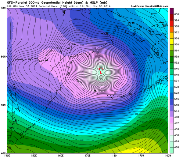
Sunday night run of the European model shows the remnants of Nuri
deepening to 920 mb in the Bering Sea, west of Alaska. The U.S. GFS
model forecast on Monday morning suggests the storm could deepen even
further, to an incredible 914 mb.
This
pressure forecast rivals the deepest extra-tropical storm on record:
the Braer Storm of 1993, which deepened to a low of 913 mb in the
North Sea. The storm takes its name from the Braer oil tanker which
was swept into Scotland’s Shetland Islands during the storm.
3:18 AM - 4 Nov 2014 Boston, MA, United States
Should
this forecast come to fruition, it would create a domino effect of
weather through North America, building a strong ridge in the western
U.S., which would drive cold, Arctic air southward into the eastern
U.S. in just over two weeks.


No comments:
Post a Comment
Note: only a member of this blog may post a comment.