The warm, dry weather returns to drought-stricken California while the rest of the US shivers and it snows in Florida.
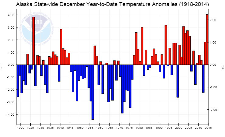
Meanwhile, little talked about, there is practically no snow in Alaska and temperatures in Anchorage over around zero Centigrade (30F).
Even less, is this contextualised in terms of what is happening to the Arctic and the Jet Stream.
The RRR ‘Ridiculously Resilient Ridge’ Returns to California
9
January, 2015
The
RRR ‘Ridiculously Resilient Ridge’ Returns to California
After a very wet first half of December hopes were high that the beginning to the end of California’s years-long drought might finally be at hand. However, virtually no rainfall has fallen across the state since December 18th and none is forecast until at least January 18th. Yet again, a month-long mid-winter dry spell has befallen the state.
Although mid-winter dry spells of two or three weeks are relatively common in California, it is rare that four or more dry weeks occur during the heart of the normally wettest time of the year December-March. During the wet season of 2012-2013 a rainy November and December (2012) came to an abrupt end by January (2013) and the drought began in earnest as a persistent high pressure ridge locked in place over the eastern Pacific (the so-called ‘Ridiculously Resilient Ridge’) and basically remained in place until February 2014. This resulted in the calendar year of 2013 becoming the driest year on record for California. During the wet season of 2013-2014 significant precipitation did not occur until February (2014) when the ridge finally broke down. In spite of the February 2014 rain and snow events, drought conditions worsened throughout the year until the heavy rains of this past December (2014) alleviated some aspects of the drought with state reservoirs gaining back around 5% of their capacities and soil moisture replenished temporarily.
 This
satellite comparison of ground conditions in California for January
2, 2014 and January 3, 2015 illustrates how the past wet December
improved soil moisture conditions in the Central Valley and snow
coverage in the Sierra. Graphic
courtesy of Thomas Niziol of The Weather Channel.
Now, it appears, the RRR has settled in once again deflecting Pacific storms to the north of California (and bringing flooding to Washington State). No precipitation is on the horizon (going out to at least January 17-18) and some locations in the state have already fallen below seasonal normal precipitation for this time of the year, this following a well above normal wet December.
 A
comparison of seasonal precipitation totals and their percentages of
normal as of December 12, 2014 (bottom table) and as of January 8,
2015 (top table) for select California cities. The list is arranged
geographically from north to south across California. By the end of
next week (around January 17th) the percentages will have slipped
even more significantly if no precipitation falls as is currently
forecast. The first half of January is historically one of the
wettest two-week periods of the year.
The snow water content in the Sierra Nevada and Cascades is also very disappointing, given all the precipitation that fell in December. At least, so far, the situation is still much better than last year at this time.
 Sierra
Nevada snow/water content for the northern mountains (Sierra and
Cascades), central Sierra, and southern Sierra zones. The blue line
is this season (2014-2015) as of January 8th compared to the last two
seasons and the historical extremes. As of January 8th the snow/water
content for all the regions statewide is 40% of normal for this
date. Data
from the California Department of Water Resources.
 The
most recent California Drought Monitor map (conditions as of January
6, 2015) illustrates that 32% of the state is still in the
‘exceptional drought’ category and 78% in the ‘extreme drought’
category. However, we can see some improvement since last October
when drought conditions peaked (58% experiencing ‘exceptional
drought’ and 82% ‘extreme drought’). NOAA/NCDC.
Not Just Dry but Warm too
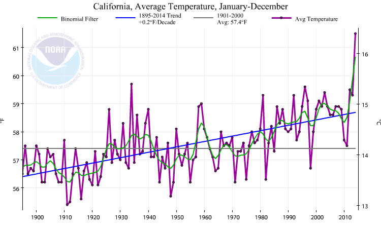
According to NOAA/NCDC, the calendar year 2014 was the warmest such on record for the state of California: by the HUGE margin of 1.8°F! The 61.5° statewide average temperature smashed the previous record of 59.7° set in 1934. December was also the warmest such on record for the state and the past few days, this January, have once again seen many daily record highs statewide. On January 6th, the temperature peaked at an amazing 91° at Camarillo in southern California (the January monthly state record remains 97° at Riverside in January 2003).
 Average
annual temperatures for California and the contiguous U.S. since
1895. Data
from NOAA/NCDC.
NOTE: I will be taking a six-week leave of absence, so this will be my last post until around February 20th.
Christopher C. Burt
Weather Historian
After a very wet first half of December hopes were high that the beginning to the end of California’s years-long drought might finally be at hand. However, virtually no rainfall has fallen across the state since December 18th and none is forecast until at least January 18th. Yet again, a month-long mid-winter dry spell has befallen the state.
Although mid-winter dry spells of two or three weeks are relatively common in California, it is rare that four or more dry weeks occur during the heart of the normally wettest time of the year December-March. During the wet season of 2012-2013 a rainy November and December (2012) came to an abrupt end by January (2013) and the drought began in earnest as a persistent high pressure ridge locked in place over the eastern Pacific (the so-called ‘Ridiculously Resilient Ridge’) and basically remained in place until February 2014. This resulted in the calendar year of 2013 becoming the driest year on record for California. During the wet season of 2013-2014 significant precipitation did not occur until February (2014) when the ridge finally broke down. In spite of the February 2014 rain and snow events, drought conditions worsened throughout the year until the heavy rains of this past December (2014) alleviated some aspects of the drought with state reservoirs gaining back around 5% of their capacities and soil moisture replenished temporarily.
Now, it appears, the RRR has settled in once again deflecting Pacific storms to the north of California (and bringing flooding to Washington State). No precipitation is on the horizon (going out to at least January 17-18) and some locations in the state have already fallen below seasonal normal precipitation for this time of the year, this following a well above normal wet December.
The snow water content in the Sierra Nevada and Cascades is also very disappointing, given all the precipitation that fell in December. At least, so far, the situation is still much better than last year at this time.
Not Just Dry but Warm too
According to NOAA/NCDC, the calendar year 2014 was the warmest such on record for the state of California: by the HUGE margin of 1.8°F! The 61.5° statewide average temperature smashed the previous record of 59.7° set in 1934. December was also the warmest such on record for the state and the past few days, this January, have once again seen many daily record highs statewide. On January 6th, the temperature peaked at an amazing 91° at Camarillo in southern California (the January monthly state record remains 97° at Riverside in January 2003).
NOTE: I will be taking a six-week leave of absence, so this will be my last post until around February 20th.
Christopher C. Burt
Weather Historian
Picture This: So Cold It Snowed in Florida
9
January, 2015
So,
it got pretty cold this week. How cold? It snowed in Florida.
But
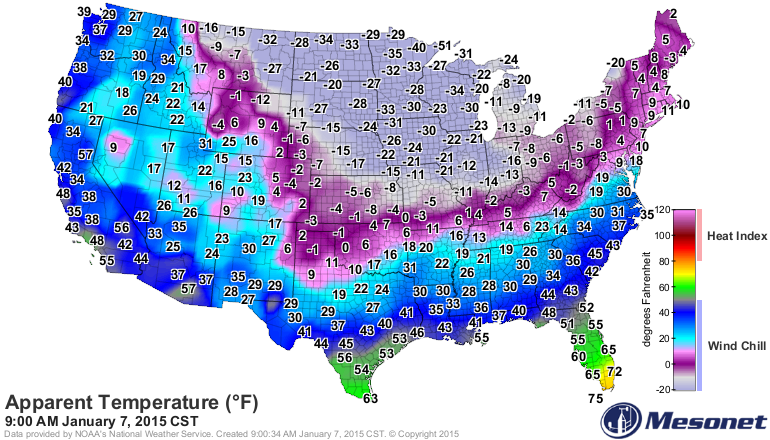
snow wasn’t the only sign of winter: Temperatures and wind chills
plummeted across much of the country as Arctic
air surged southward,
leading to some stunning maps, teeth-chattering sights and serious
bundling up. As a country, that cold was offset by record warm
temperatures in the western U.S., coming just after a record hot year
for some western states.
But
first, that snow in Florida.
Sunshine State Snow
As
the Arctic air pushed further and further south across the country,
that cold air met the relative warmth of the ocean waters off
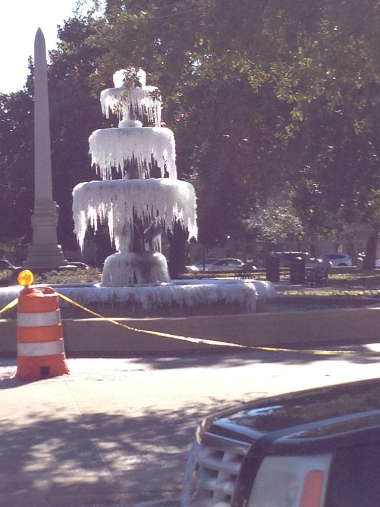
Florida’s northeast coast. That air was so cold it froze the water
in a fountain in Pensacola:
Like
the lake
effect snow common
around the Great Lakes in winter (and which buried
Buffalo in
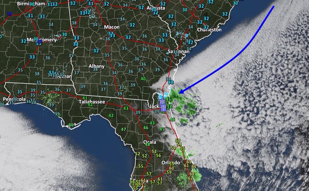
November during a particularly strong event), this “ocean effect”
snow is a product of that temperature discrepancy between air and
water. As the cold air sweeps over the ocean, water evaporates and
warms the air layer just above the ocean. That warm air rises,
cooling as it does so, until it reaches the point where the water in
it freezes and falls as snow. If the winds blow onshore, that snow
falls on land, as you can see in this radar image:
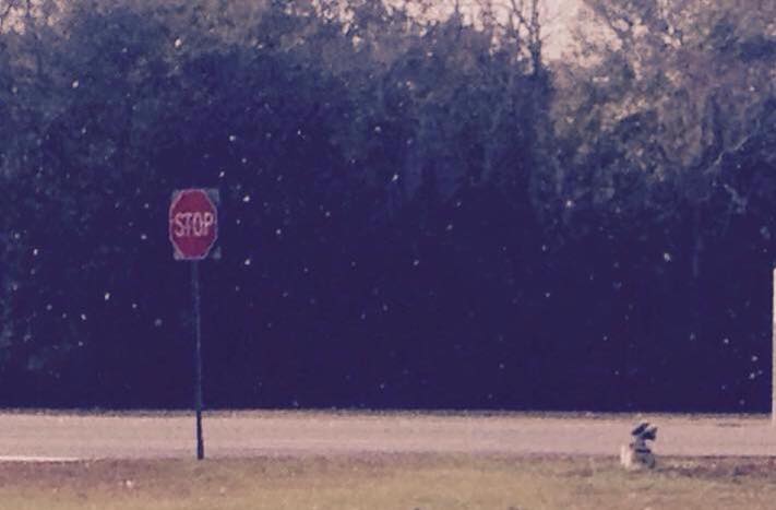
And
that’s how you get scenes like this one in Jacksonville:
Big (Frozen) Picture:
As
always, some of the best images of the Arctic takeover came from
space and nationwide maps that showed the extent of the deep freeze.
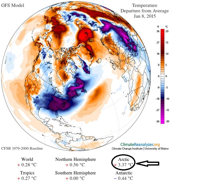
This map shows how much colder much of the country was compared to
average for January:
(Note,
though, how much warmer the Arctic is at the same time.)
On
Wednesday, as the cold air seeped southward, the temperature
difference across the U.S. was an amazing 126°F:
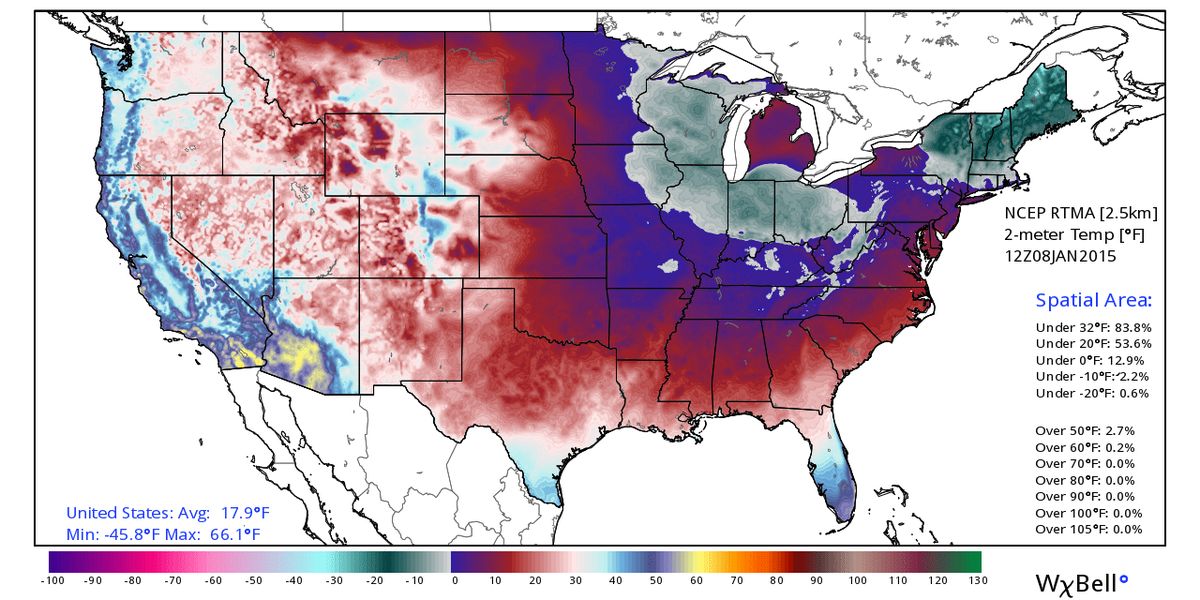
On
Thursday, the national map showed that more than three quarters of
the continental U.S. was below freezing, with an average temperature
of just 17.9°F. Ouch.
But
the best view came courtesy of the Suomi
NPP satellite,
which can take nighttime shots of the country. It spotted the snow
that blanketed the northern tier of states along with the bright
lights of urban areas:
 Snow
blankets parts of the eastern U.S. in this image taken Thursday by
the Suomi NPP satellite.
Credit: NASA/NOAA
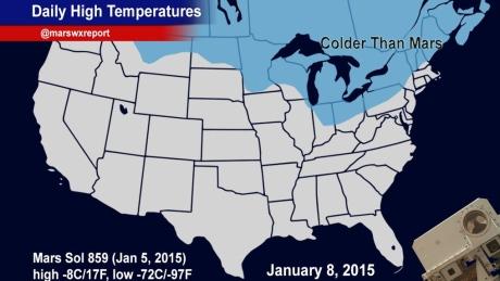
Colder
than Mars
Credit: NASA/NOAA
Wind
chills dipped so low across parts of Canada and the northernmost U.S.
that they
Western Warmth
Of
course, while everyone east of the Rockies was bundled up like this:
Folks
out West were enjoying some record-warm temperatures, with parts of
Arizona and California reaching into the 80s, including Phoenix,
which was hosting the annual meeting of the American
Meteorological Society.
Well played, meteorologists.
Those
temps continued a trend of anomalous
warmth all
through 2014 in the western states. It was announced this week that
both California and Alaska had record-hot years last year:
Let It Snow
Going
back to the cold, not everyone minded the wintry weather. The
ever-industrial students of Georgia
Tech decided
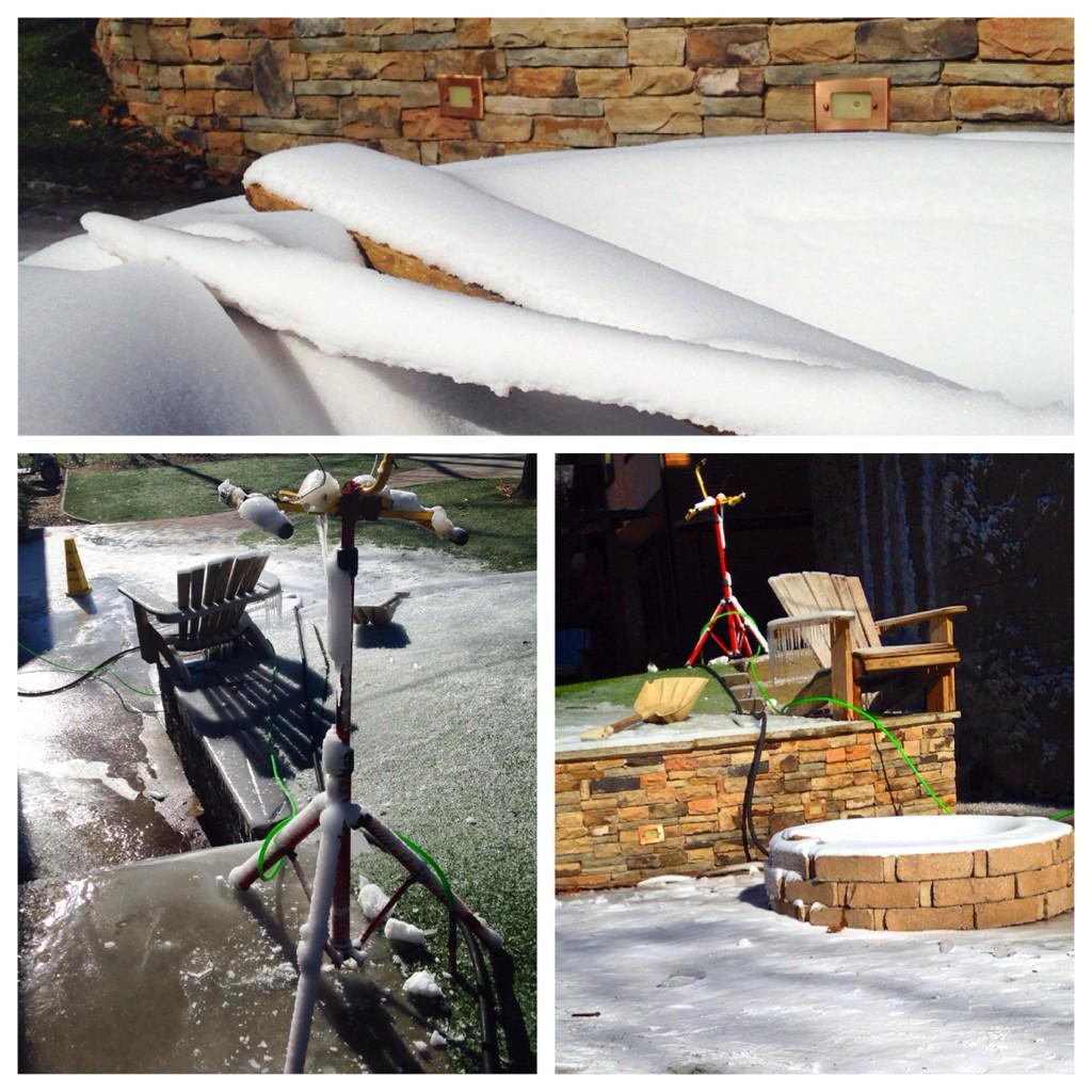
to take advantage of the chill to make their own snow day:
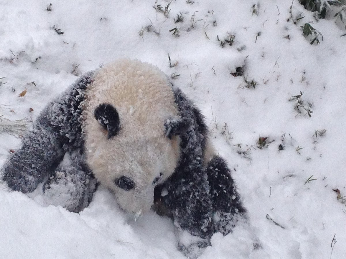
And to end the week on a much-needed cute note, the National Zoo’s baby panda, Bao Bao, got her first taste of snow. The verdict? She loved it:















ReplyDeleteOur appointment is to bring quality cannabis as medicine to anybody everywhere who needs it! From our more years of involvement, we know that cannabis is not consistently the easiest thing so we are here to cause it easy.
psychedelicsheadshop