

There are live updates on cyclone Pam from both Stuff and Radio NZ
This has been an absolute catastrophe for Vanuatu and the entire region. There was the expectation that Pam could vear off to the SE, or the worst-case scenario of it following a north-south trajectory.
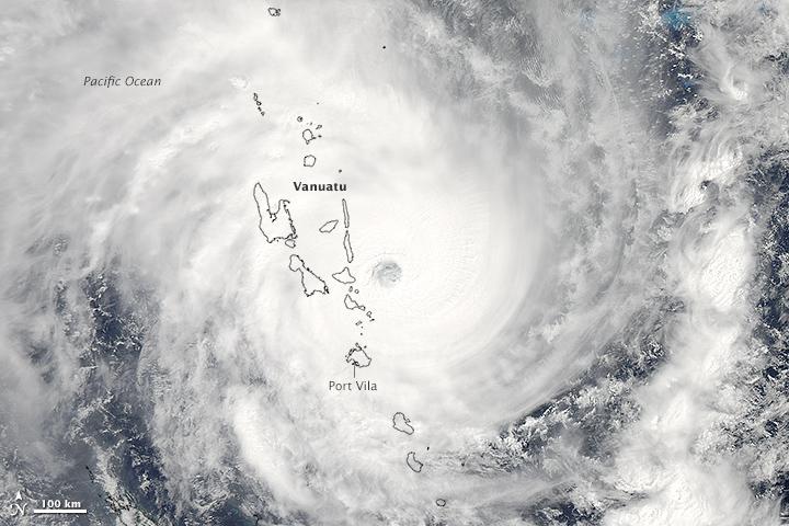
As we now know it followed the worst-case scenario, cutting a swathe of devastation through the islands of the archipelago.
We know what the situation in Port Vila is, that has many concrete building, but still have no idea of the real extent of the damage and loss of lives throughout the other islands - but we know it will be unprecedented.
Those of us who are willing to mention the elephant in the room, know that this is not the last time that this sort of destruction will be visited upon the Pacific. This is but the beginning of abrupt climate change that is going to be disastrous for the Pacific - and for us all.
In the medium future, it looks as if these storms are going to give a nudge to the "weak" el-Nino and make a serious situation worse.
For the real clues we need to look far to the north, to the Arctic.

This has been an absolute catastrophe for Vanuatu and the entire region. There was the expectation that Pam could vear off to the SE, or the worst-case scenario of it following a north-south trajectory.
As we now know it followed the worst-case scenario, cutting a swathe of devastation through the islands of the archipelago.
We know what the situation in Port Vila is, that has many concrete building, but still have no idea of the real extent of the damage and loss of lives throughout the other islands - but we know it will be unprecedented.
Those of us who are willing to mention the elephant in the room, know that this is not the last time that this sort of destruction will be visited upon the Pacific. This is but the beginning of abrupt climate change that is going to be disastrous for the Pacific - and for us all.
In the medium future, it looks as if these storms are going to give a nudge to the "weak" el-Nino and make a serious situation worse.
For the real clues we need to look far to the north, to the Arctic.
Update
on Cyclone Pam
This was an excellent on-the-ground update on the humanitarian situation in Vanuatu.
Stuff,
16 March, 2014
What you need to know:
- Cyclone Pam has been reclassified as an “intense extra tropical cyclone”
- The storm is expected to peak around midday in Gisborne as Pam passes the east of NZ
- A number of schools are closed in Gisborne and Bay of Plenty as the storm approaches.
- More than a thousand Auckland homes lost power overnight.
- Vector says power has now been completely restored.
- Aid workers arriving in Vanuatu have described the situation in the Pacific Island as catastrophic.
via
·
6 minutes ago

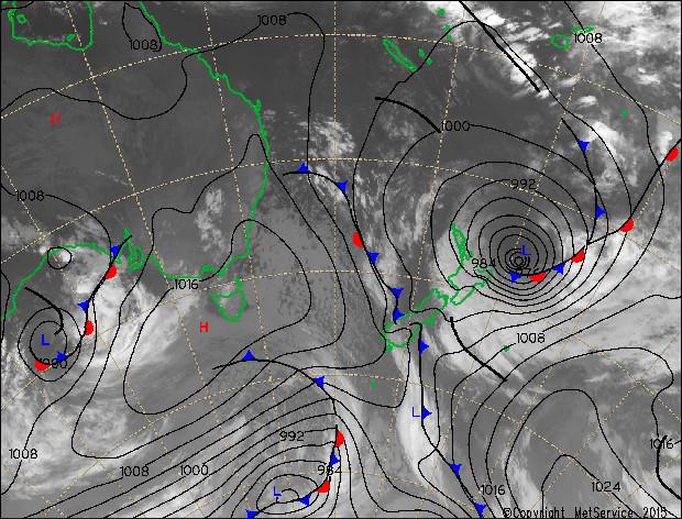
The 7am analysis & satellite image for Cyclone Pam northeast of East Cape. SAT loop here: metservice.com/maps-radar/sat… ^CN pic.twitter.com/VFoSXMTQxf

Gisborne update: No road issues reported this morning. GDC urge people not to travel unless absolutely necessary-ow.ly/Kmlpj ^LGG
Roading update - We have a report that The 309 Road - 8km from Whitianga end of the road.is closed. We will post... fb.me/4uqCIAQJt

Heavy rain predictions for Coromandel have been upgraded to a warning level with 70 - 90mm expected between 9am Monday and 9am Tuesday.
via
·
about an hour ago

Ex-Cyclone Pam is making itself felt at Te Araroa, near Gisborne. Photo/Trent Fearley
via
·
about an hour ago
Gisborne Civil Defence said all schools in the Gisborne region were thought to be closed today.
"The rain falling throughout the district is just a warm-up. We expect the wind and sea to start rising late morning, and the severity of the event to be greatly lessened by later today," it said around 8am Monday.
Linesmen were working to restore power in three rural areas.
Trouble spots were being closely monitored at Tokomaru Bay and Anaura Bay, where there were concerns about coastal erosion, sea inundation and flooding.
via
·
about an hour ago
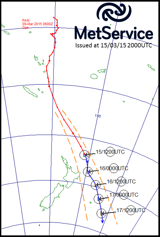
Where next? Here's the latest forecast for Pam moving southeast. Times in UTC, add 13 hours to get local times. ^JL pic.twitter.com/nlX5DC9PkZ
Aid workers arriving in Vanuatu have descbied the situation in the Pacific Island as catastrophic.
Here's the latest on the situation in Vanuatu.
via
·
about an hour ago


Images of destruction are emerging from our colleagues on the ground in Port Vila, #Vanuatu. #CyclonePam #TCPam pic.twitter.com/P6SxJJPl5y
Prime Minister John Key says two air force planes will head to Vanuatu with relief supplies, after Cyclone Pam wreaked devastation on the country.
The planes packed with emergency supplies were part of New Zealand's aid package, which included $2.5 million pledged by Foreign Affairs Minister Murray McCully.
The planes packed with emergency supplies were part of New Zealand's aid package, which included $2.5 million pledged by Foreign Affairs Minister Murray McCully.
via
·
about an hour ago

People look out to sea from Moturiki Island at Mount Maunganui as Cyclone Pam bears down on the East Coast of the North Island.
via
·
about an hour ago
Gisborne is braced for the storm which is expected to peak around midday Monday.
"We've had a reasonable amount of rain already and the wind looks like it's trying to pick up," Gisborne manager emergency management Richard Steele said about 8am.
There were no reports of any damage.
At Tolaga Bay - identified along with Tokomaru Bay as likely to bear the brunt of the storm - resident Mike Brooker said the winds and sea conditions were starting to pick up.
"We haven't had a great deal of rain overnight but the waves have started to break over the end of the wharf and it's nowhere near high tide," Brooker said.
"At the moment it's looking like a normal storm, but we're nowhere near the peak of it."
via
·
about an hour ago

Last #TCPam update tonight. 120km/hr wind in upper Gulf & 3m waves, expected to increase overnight #alltoforecast pic.twitter.com/e4Rp8vYkV0
Northland Civil Defence Emergency Management Group controller Tony Phipps said Northland appeared to have escaped the aftermath of the cyclone "largely unscathed".
At 7.15am officials had no reports of serious damage or injury, he said.
"Emergency services have reported a quiet night with few storm-related incidents, although daylight may reveal some damage that we are as-yet unaware of, given the heavy seas off Northland's coast overnight."
Rainfall in Northland had reached 67.5mm at Glenbervie, east of Whangarei, this morning and the maximum wind gust was 118.5kph, in Cape Reinga.
via
·
about an hour ago
The seas off Whakatane, in the eastern Bay of Plenty, were as rough as coastal resident had seen for a considerable time.
Civil Defence checks of the coast east from Whakatane as far as the East Coast reportedly had so far found no significant damage.
It was not yet raining, local Megan Hunt said.
Civil Defence checks of the coast east from Whakatane as far as the East Coast reportedly had so far found no significant damage.
It was not yet raining, local Megan Hunt said.
via
·
about 2 hours ago

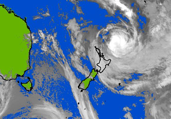
Cyclone Pam sits off the north east of the North Island in this image from EarthWindMap.
via
·
about 2 hours ago
Around 7am Whakatane District Council said the weather so far had not been nearly as bad as was forecast, but residents should still be cautious, particularly in coastal areas.
Big swells remained possible, particularly near high tide.
Big swells remained possible, particularly near high tide.
via
·
about 2 hours ago
Are you in a storm-affected area? Send your photos and video to newstips@stuff.co.nz.
via
·
about 2 hours ago
Cyclone Pam doesn't appear to have wreaked too much havoc in the Coromandel Peninsula or Bay of Plenty, but residents are being warned not to let their guard down.
Meteorologist Hordur Thordarson said “extremely strong wind gusts, heavy rain and phenomenal waves are still expected”.
The Thames-Coromandel District had heavy winds in the early morning but fared better than expected overnight.
"Looks like we dodged the bullet overnight in terms of what it could have been," said an early post on the council's Facebook page. "Still have full warnings in place though."
The Emergency Operating Centre was stood down but teams were on standby in Coromandel Town, Whangamata, Whitianga, Tairua-Pauanui, Whiritoa and Waihi.
At least five schools in the district are closed and the council is asking residents not to put their recycling bins out
And Bay of Plenty Civil Defence warned residents not to let their guard down.
"It might seem calmer than you expected but it's still early yet," a Facebook post said.
Metservice advice had put a window of between 1am and 10pm Monday on wild weather, it said.
At least five Bay of Plenty schools were closed.
via
·
about 2 hours ago

CYCLONE PAM: AUCKLAND UPDATE 144km/hr winds recorded near GBI o/night. No major incidents reported. More here: facebook.com/pages/Auckland…
#TCPam making its way on to northern New Zealand at 1pm @MetService imagespic.twitter.com/yZYRUKMYGG
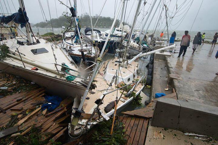
The first aid teams to reach Vanuatu reported widespread devastation on Sunday as authorities declared a state of emergency after a "monster" cyclone tore through the Pacific island nation.
With winds of more than 300kmh, Cyclone Pam razed homes, smashed boats and washed away roads and bridges as it struck late on Friday and into Saturday. Aid workers described the situation as catastrophic.
- Source: Reuters
via
·
about 3 hours ago
Auckland Civil Defence controller Clive Manly said the brunt of the storm had reached further out to sea than expected and there had been no reports of damage on land.
Swells at Great Barrier Island had reached 3.4m and winds had gusted to about 80kmh in Whangaparaoa and up to 145kmh on Great Barrier Island, which Manly said was significantly less than expected.
"We got off really lightly during the night. We expected tree damage but there were no reports of any," he said.
via
·
about 3 hours ago

Latest reports on #CyclonePam via @reliefweb: bit.ly/1wHTVMd #TCPam Image:1.usa.gov/1wHTTnq #Vanuatu pic.twitter.com/1HkV5H5XsF

Latest from @reliefweb on #TCPam destruction in #Vanuatu: reliefweb.int/disaster/tc-20… pic.twitter.com/4uKFJYEzRQ
via @UNOCHA (@UNICEF photos)
via @UNOCHA (@UNICEF photos)
In the Far North, Top Energy spokesman Peter Heath said it was "remarkable" how few outages there were. A maximum of 1200 customers had experienced power cuts since Sunday night but crew had worked overnight to restore lines, leaving just 49 people without power in Hokianga at 6.30am. Most of the cuts were due to trees on lines or lines across roads, he said.
No comments:
Post a Comment
Note: only a member of this blog may post a comment.