

Warm
Storms Rage Through Barents as Arctic Sea Ice Enters 13th Day of
Record Low Extent
16 March, 2015
On
March 4, amidst a building polar heat amplification and a strong,
thousands mile long, south to north wind and storm flow across the
North Atlantic and into the Arctic, sea ice extent coverage for the
northern polar region plunged to new record lows.


(26
foot wave heights [left frame] and 50-60 mph sustained southerly
winds [right frame] in conjunction with warm storm near the ice edge
at Svalbard on March 16, 2015. Storms of this kind have been raging
up through the Barents delivering powerful, warm southerly winds and
immense swells to the ice edge region for at least the past half
month. This strong melt pressure and warm air delivery has
contributed to record low sea ice extent totals continuing for the
past 13 days running. Image source: Earth
Nullschool.
Data source: GFS.)
Human-forced
heat continued to build throughout the Arctic as warm and intensely
windy storms churned northward through the Barents, bringing with
them powerful swells ranging from 15 to, at times, 40 feet in height.
As these great swells ground away at the ice edge, temperatures hit
daily anomalies greater than 4 C above the 1979-2000 average on
Sunday, March 8 for the entire Arctic region. The next day, sea ice
extent, according to NSIDC, plummeted to 14,273,000 square
kilometers. A value 303,000 square kilometers, or an area about the
size of Arizona, smaller than the previous record low value for the
date set in 2006.
Ever
since March 4, the Arctic has remained in new record low territory —
a period that has now lasted 13 days. Though anomalous warmth has
faded somewhat — dropping today to a range of 2.65 degrees Celsius
above the 1979-2000 average — sea ice has only bounced back
slightly. On March 15, the NSIDC extent measure had inched up to
14,333,000 square kilometers, still about 235,000 square kilometers
below the previous record low for the date.
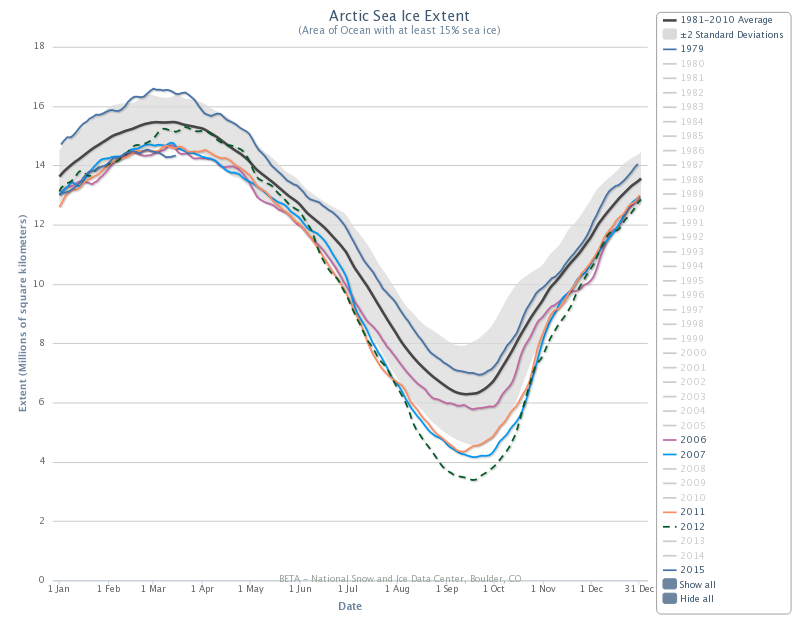
(Arctic
sea ice extent as measured by NSIDC drops below previous record low
values on March 4 of 2015 [bottom dark blue line] and has remained at
record low levels ever since. For reference, previous record low
years for March dates include 2006 [pink line], 2007 [light blue
line], and 2011 [orange line]. The top dark blue line [1979]
indicates how much sea ice extent has been lost during March over the
past 36 years. Image source: NSIDC.)
Over
the next week, however, these new record lows are more likely to
continue to fade as warm Arctic surface temperature anomalies drop to
around 1-2 C above average, the Arctic Oscillation shifts toward
neutral or slightly negative, and the warm storm track through the
Barents is interrupted by cold winds pushing south toward Scandinavia
from the pole. Although mid-week warming forecast for Alaska and
Baffin Bay may retard any potential rebound somewhat.
For
the past two years, Arctic sea ice has experienced a bit of a rebound
during the March through early April time-frame. This has appeared to
coincide with a restrengthening of the polar Jet Stream as mid
latitudes have warmed which, in turn, has weakened meridional
patterns transporting heat into the Arctic during winter time. Low
angle sunlight entering the Arctic at this time of year has also not
yet gained enough momentum to significantly push the ice to melt. So
we still have about a 2-3 week window for potential bounce-back
before sunlight builds and begins to apply its steady heat forcing to
the greatly diminished ice.

(Arctic
Oscillation [AO] index forecast shows dip toward slightly negative or
neutral AO status by end week after a rather extreme high in early
March, with a return to mildly positive AO values by end month.
Positive AO enhances edge melt of sea ice by encouraging storm
formation at the ice edge and warm air invasions over the central
ice. Image source: NOAA/CPC.)
That
said, the ice is quite frail now, even with potential volume rebounds
to mid 2000s levels. So even the slight addition of solar insolation
may be enough to keep ice coverage values depressed in the neutral or
moderately positive Arctic Oscillation regime that is predicted
through the end of March. Extent measures maintaining near record
lows along the 2006, 2007 and 2011 tracks, or just below, would
establish a very low launching pad for a melt season that, lately,
has tended to include precipitous declines in ice during the summer
months.
The
ongoing record low extent status, despite a return to weather
patterns that are more favorable for rebound or maintenance,
therefore, should be closely monitored.
Links:
No comments:
Post a Comment
Note: only a member of this blog may post a comment.