

Halfway to 2 C — According to NASA, We Just Blew Past an Ominous Milestone
15
July, 2015
2
C.
It’s
the amount of warming past pre-industrial times that the IPCC says we
should try to avoid this Century in order to prevent the worst
consequences of human-caused climate change. It’s the so-called
safe limit, even though there’s nothing really safe about it and we
should probably be aiming more for a below 1.5 C target.
1
C.
It’s
the amount of warming between pre-industrial times and, according
to the latest data from NASA,
the first half of 2015. In other words, temperatures during the first
six months of 2015 are now at least halfway toward freeing some of
the nastiest climate monsters in the closet.
*
* * * *
According
to NASA
GISS,
June of 2015 was tied with 1998 as the hottest of any June in the
entire 135 year global climate record. Coming in at +0.76 C above
NASA’s 20th Century average, June follows May at +0.73 C (4th
hottest), April at +0.71 C (tied for 3rd hottest), March at +0.91 C
(second hottest), February at + 0.89 C (hottest), and January at
+0.81 C (2nd hottest).
Combined,
these average out for a +0.80 C departure from the 20th Century in
the NASA measure. That’s an extraordinary amount of heat — +0.18
C above 1998 levels and +0.05 C above 2014, which was the previous
hottest year on record.
But,
perhaps most importantly, this reading is the first consistent break
at 1 C above 1880s levels. An ominous benchmark and halfway to the
catastrophic 2 C warming we really, really want to avoid.
June
Takes On El Nino-Type Temperature Pattern
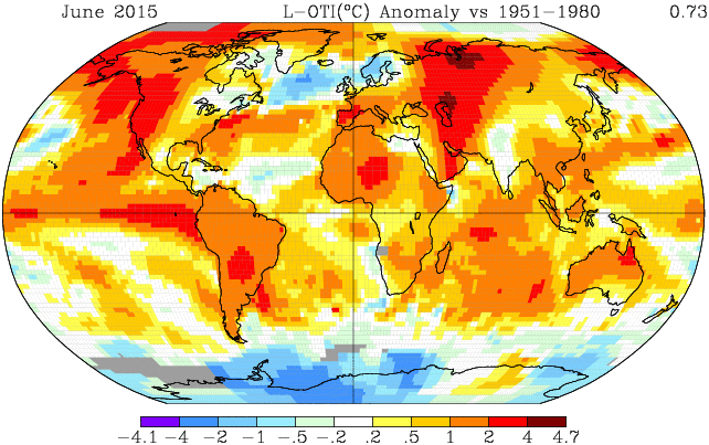
Looking
at the June temperature anomaly map, we find very large zones of 2-4
C above average readings running up toward the Northern Hemisphere
Pole. The first of these zones rides up over Western Asia. Covering
most of the region from the Caspian Sea on northward, this area
features two anomalously hot zones ranging to as high as a +4.7 C
anomaly in intensity. The second of these zones issues from the
developing El Nino in the Eastern Pacific, rides up over the hot
‘Blob’ of ocean water in the Northeastern Pacific, invades Alaska
and the Pacific Northwest, and then enters the Beaufort and Chukchi
seas. This zone also features large expanses of +2 to +4 C above
average temperatures.
Overall,
most of the globe saw above average readings with only the region
just south of Greenland, a small zone just west of the hot ‘Blob,’
and an area of somewhat cooler readings over West Antarctic showing
below average readings.
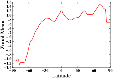
(Zonal
anomalies began to pick up the El Nino signal during June. Note that
equatorial heat gain nearly matches that of the Northern Hemisphere
pole. Image source: NASA
GISS.)
Under
El Nino — a climate condition the globe is steadily
transitioning toward — we would expect to see relative warming near
the Equator and relative cooling near the poles. During June, we
begin to see this signature with the Equator warming up to a
substantial +1.2 C positive anomaly. Antarctica also followed this
trend as that polar zone dipped into the -0.4 to -1.2 C negative
anomaly range (60 to 90 South). Meanwhile, the Northern Hemisphere
Polar zone (60 to 90 North) showed significant hot readings in the
range of +0.9 to +1.4 C anomalies.
Overall,
the entire globe from 50 South on northward experienced above average
to much hotter than average temperatures in the zonal measure. A
clear and powerful heat signal for June of 2015.
Building
El Nino Likely Means More Heat to Come
With
the first six months of 2015 finished and with El Nino still
strengthening in the Pacific, it appears that a record hot year may
already be a lock. In addition, further warming may be in store.
The
current El Nino appears to be roughly on a similar development track,
as far as timing and possible intensity, to the 1997-1998 El Nino.
Given this rough allegory, we are approximately at the same place,
climatologically speaking, as July of 1997. During that event, global
temperatures didn’t really start taking off into severe record high
ranges until Fall of 1997 through Summer of 1998. If the ocean to
atmosphere heat loading for the current event proceeds in similar
fashion, we could expect to see even more extreme temperatures than
we are currently experiencing by Fall and running on through at least
the first season or two of 2016.
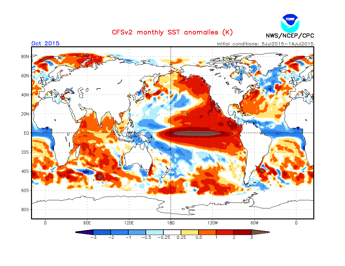
(Record-breaking
El Nino by October? NOAA CFSv2 models have been spitting out some
pretty extreme results. If we see anywhere near this level of sea
surface warming the Central Pacific, the heat records thus far for
months during 2014 and 2015 may soon be left in the dust. Image
source: NOAA
CPC.)
Looking
toward July’s forecast, there is a bit of a caveat. That month is
typically cooler globally due to a lessed impact of the greenhouse
gas heat forcing. This is due to the fact that greenhouse gasses are
concentrated most heavily in the Northern Hemisphere and such
greenhouse gasses are most efficient at heat trapping during night
time and winter. As such, we may see a bit of a dip in the July
readings below June. But if this current El Nino gets involved as the
models predict, it’s likely to be record-breaking heat that pushes
some very ominous global temperature thresholds all the way through
from August 2015 to at least early 2016.
Let’s
just hope we don’t close too much more of the gap to 2 C. It’s
really starting to get scary out there.
Links:
Hat
tip to Wili
(Please
support public, non-special interest based, science like the
fantastic work written about here and conducted by the experts at
NASA and NOAA.)
No comments:
Post a Comment
Note: only a member of this blog may post a comment.