Strong Westerlies Push El Nino Toward Extreme Event
Robertscribbler,
3 July, 2015
For the past two weeks, winds have been blowing in an anomalous west-to-east pattern across the Western Pacific. It’s the third such pattern since El Nino conditions began to become more prevalent during March of this year. And forecast model response to the most recent westerly wind burst is an overall shift toward predicting a record event. Models are starting to settle on at least a strong El Nino come fall (1.5 degree Celsius anomaly or greater for Nino 3.4) with many ensembles predicting something even more intense than the super El Nino of 1998.
This third, El Nino heightening, westerly wind burst (WWB) coincided with a strong, wet variation of the Madden Julian Oscillation pumping up thunderstorm activity throughout the region. Last week, a consistent 20-35 mph westerly wind pattern had become very well established. Over the past four days, multiple cyclones became embedded within the pattern, which now stretches over 3,000 miles in length, pushing locally stronger winds and reinforcing the already significant wind field.
By today four cyclonic systems, including Typhoon Chan-Hom, had further heightened westerly wind intensity:

(The current strong westerly wind burst is looking more and more like the extreme event of early March of this year. It’s the third such event — one that is increasing the likelihood that the 2015 El Nino will be one more for the record books. Image source: Earth Nullschool.)
It’s a pattern that in today’s map looks very similar to the record event which occurred this Spring. And it’s the third significant WWB to initiate since March of this year.
WWBs push warm surface water in the Western Pacific downward and across the ocean (read more about how WWBs affect El Nino severity here). These warm water pulses traverse thousands of miles, finally resurfacing in the Eastern Pacific off South America. The resultant warming of surface waters there and through the mid ocean region tends to set in place ocean temperature and atmospheric patterns that reinforce El Nino — driving more westerly winds and still more warm water displacement eastward.
Three westerly wind bursts firing off since March of 2015 have pushed increasingly strong El Nino conditions. A warming of the Equatorial Pacific that, in combination with a massive and rapidly growing greenhouse gas overburden from human fossil fuel burning, is forcing global temperature readings to hit new record high after new record high.

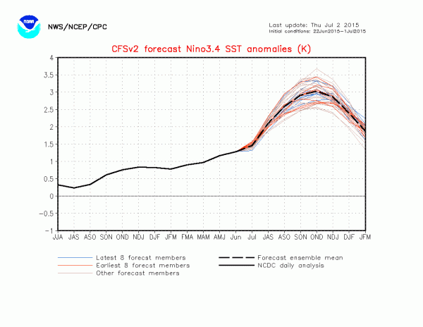
(CFSv2 Model runs are pointing toward a very powerful anomaly come Fall. Image source: Climate Prediction Center.)
This third strong westerly wind burst appears to have again pushed model forecasts into very extreme ranges for Fall of this year. NOAA’s CFSv2 ensembles now predicts a peak sea surface temperature anomaly in the range of 2.5 degrees Celsius above average to 3.1 degrees Celsius above average. An El Nino of this strength would be significantly stronger than the monster event of 1998. One that would occur in a global context that includes an approximate 45 parts per million CO2e worth of heat trapping gas accumulation since that time. One that is now in the range of 1 C warming above 1880s averages (or 1/4th the difference between now and the last ice age, but on the side of hot).
Since we are now well past the spring predictability barrier, these new model runs have a higher potential accuracy. That said, we are still four months out and a number of additional factors would have to come into play to lock in such a powerful event. However, the trend is still for a strong to extraordinarily powerful El Nino. And since such an event is occurring in a record warm atmosphere and ocean environment (due to human-caused climate change), the continued potential for related additional anomalous weather events (drought, flood, wildfires, extreme tropical cyclones in the Pacific, etc) is also high enough to remain a serious concern.
Links:
NOAA’s Climate Prediction Center
Earth Nullschool
Strong Influence of Westerly Wind Bursts on El Nino Diversity


No comments:
Post a Comment
Note: only a member of this blog may post a comment.