

West
Antarctic Ice Sheet News
date?
You
may have heard the
news:
two teams of scientists claiming that the West Antarctic Ice Sheet
has been irreversibly destablized, leading to a slow-motion process
that in some number of centuries will cause 3 meters of sea level
rise.
“Today
we present observational evidence that a large section of the West
Antarctic Ice Sheet has gone into irreversible retreat,” an author
of one of the papers, Eric Rignot, a glaciologist at NASA’s Jet
Propulsion Laboratory, said at a news conference recently. “It has
passed the point of no return.”
A
little context might help.

The West
Antarctic Ice Sheet is
the ice sheet that covers Antarctica on the Western Hemisphere side
of the Transantarctic Mountains. The bed of this ice sheet lies well
below sea level. The ice gradually flows into floating ice shelves
such as the Ross Ice Shelf and Ronne Ice Shelf, and also glaciers
that dump ice into the Amundsen Sea. Click on the map to make it
bigger, so you can see all these features.
The
West Antarctic Ice Sheet contains about 2.2 million cubic kilometers
of ice, enough to raise the world’s oceans about 4.8 meters if
it allmelted. To get a sense of how big it is, let’s
visit a crack in one of its outlet glaciers.

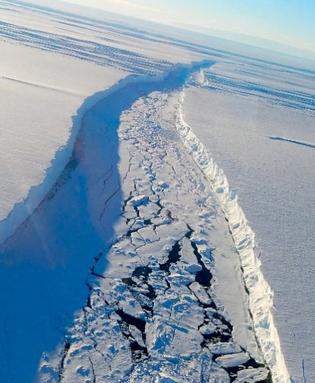
In
2011, scientists working in Antarctica discovered a massive crack
across the Pine Island Glacier, a major glacier in the West Antarctic
Ice Sheet. The crack was 30 kilometers long, 80 meters wide and 60
meters deep. The pictures above and below show this crack—the top
one is from NASA,
the bottom one was taken by an explorer named Forrest
McCarthy.
By July
2013,
the crack expanded to the point where a slab of ice 720 square
kilometers in size broke off and moved into the Amundsen Sea.
However,
this event is not the news! The news is about what’s happeningat
the bottom of the glaciers of the West Antarctic Ice Sheet.
The
West Antarctic Ice Sheet sits in a bowl-shaped depression in the
earth, with the bottom of the ice below sea level. Warm ocean water
is causing the ice sitting along the rim of the bowl to thin and
retreat. As the edge of the ice moves away from the rim and enters
deeper water, it can retreat faster.

So,
there could be a kind of tipping point, where the West Antarctic Ice
Sheet melts faster and faster as its bottom becomes exposed to more
water. Scientists have been concerned about this for decades. But now
two teams of scientists claim that tipping point has been passed.
Here’s
a video that illustrates the process:
And
here’s a long quote from a short ‘news and analysis’ article by
Thomas Sumner in the 16 May 2014 issue of Science:
A disaster may be unfolding—in slow motion. Earlier this week, two teams of scientists reported that Thwaites Glacier, a keystone holding the massive West Antarctic Ice Sheet together, is starting to collapse. In the long run, they say, the entire ice sheet is doomed. Its meltwater would raise sea levels by more than 3 meters.
One team combined data on the recent retreat of the 182,000-square-kilometer Thwaites Glacier with a model of the glacier’s dynamics to forecast its future. In a paper on page 735, they report that in as few as 2 centuries Thwaites Glacier’s edge will recede past an underwater ridge now stalling its retreat. Their models suggest that the glacier will then cascade into rapid collapse. The second team, writing in Geophysical Research Letters, describes recent radar mapping of West Antarctica’s glaciers and confirms that the 600-meter-deep ridge is the final obstacle before the bedrock underlying the glacier dips into a deep basin.
Because inland basins connect Thwaites Glacier to other major glaciers in the region, both research teams say its collapse would flood West Antarctica with seawater, prompting a near-complete loss of ice in the area over hundreds of years.
“The next stable state for the West Antarctic Ice Sheet might be no ice sheet at all,” says the Science paper’s lead author, glaciologist Ian Joughin of the University of Washington, Seattle. “Very crudely, we are now committed to global sea level rise equivalent to a permanent Hurricane Sandy storm surge,” says glaciologist Richard Alley of Pennsylvania State University, University Park, referring to the storm that ravaged the Caribbean and the U.S. East Coast in 2012. Alley was not involved in either study.
Where Thwaites Glacier meets the Amundsen Sea, deep warm water burrows under the ice sheet’s base, forming an ice shelf from which icebergs break off. When melt and iceberg creation outpace fresh snowfall farther inland, the glacier shrinks. According to the radar mapping released this week inGeophysical Research Letters from the European Remote Sensing satellite, from 1992 to 2011 Thwaites Glacier retreated 14 kilometers. “Nowhere else in Antarctica is changing this fast,” says University of Washington Seattle glaciologist Benjamin Smith, co-author of the Science paper.
To forecast Thwaites Glacier’s fate, the team plugged satellite and aircraft radar maps of the glacier’s ice and underlying bedrock into a computer model. In simulations that assumed various melting trends, the model accurately reproduced recent ice-loss measurements and churned out a disturbing result: In all but the most conservative melt scenarios, a glacial collapse has already started. In 200 to 500 years, once the glacier’s “grounding line”—the point at which the ice begins to float—retreats past the ridge, the glacier’s face will become taller and, like a tower of blocks, more prone to collapse. The retreat will then accelerate to more than 5 kilometers per year, the team says. “On a glacial timescale, 200 to 500 years is the blink of an eye,” Joughin says.
And once Thwaites is gone, the rest of West Antarctica would be at risk.
Eric Rignot, a climate scientist at the University of California, Irvine, and the lead author of the GRL study, is skeptical of Joughin’s timeline because the computer model used estimates of future melting rates instead of calculations based on physical processes such as changing sea temperatures. “These simulations ought to go to the next stage and include realistic ocean forcing,” he says. If they do, he says, they might predict an even more rapid retreat.
I
haven’t had time to carefully read the relevant papers, which are
these:
•
Eric
Rignot, J. Mouginot, M. Morlighem, H. Seroussi and B.
Scheuchl,Widespread,
rapid grounding line retreat of Pine Island, Thwaites, Smith and
Kohler glaciers, West Antarctica from 1992 to 2011, Geophysical
Research Letters,
accepted 12 May 2014.
•
Ian
Joughin, Benjamin E. Smith and Brooke Medley, Marine ice sheet
collapse potentially underway for the Thwaites glacier basin, West
Antarctica, Science, 344 (2014),
735–738.
I
would like to say something more detailed about them someday.
The
paper by Eric Rignot et al. is freely available—just
click on the title.
Unfortunately, you can’t read the other paper
unless you have a journal subscription. Sumner’s article which I
quoted is also not freely available. I wish scientists and the
journal Science took more seriously their duty to
make important research available to the public.
Here’s
a video that shows Pine Island Glacier, Thwaites Glacier and some
other nearby glaciers:
No comments:
Post a Comment
Note: only a member of this blog may post a comment.