

Wrecked Pacific Storm Track Now Runs From Equator to Arctic Ocean
12
August, 2015
There’s
something not quite right going on in the Pacific.
In
the northeast of that great ocean, the Ridiculously
Resilient Ridge just
keeps growing. A gigantic high pressure cell spreading out to
encompass the entire region from the Aleutians to just off the
California Coast. This giant, implacable system has lasted now for
the better part of two years. A mountain of atmospheric inertia
towering over a deadly, human-warmed,
hot pool of Pacific Ocean water.
A
Not Normal Storm Track
To
the west of our monstrous ridge runs an abnormal storm track. Firing
off just north of the Equator and south and east of Japan, the track
is fed by tropical systems swinging north and eastward. Merging
frontal storms with the warm core cyclones, this storm track runs up
along the boundary of the Northwest Pacific and into the Bering. Many
of these storms end up bottled there. But a few surge over into the
Chukchi and East Siberian seas. In this way, heat and moisture that
originated in the tropics is eventually delivered to the Arctic.
Exactly the kind of south to north heat and storm potential energy
delivery that Dr.
Jennifer Francis has been warning us about.
Over
the next few days, this storm, heat, and moisture conveyor belt will
continue to lend energy to systems firing off over the Pacific side
of the Arctic. These storms will generate winds of 25 to 35 miles per
hour with higher gusts. They’ll send swells in the range of 4-7
feet rippling across the still ice-smattered waters. And they’ll
fling rain, sleet, freezing rain and snow over the still melting ice.
An unsettled pattern featuring cold-core systems with an intensity
comparable to tropical depressions but firing off in the chill
boundary zones along the sea ice melt edge.
Ridge
Forms South-to-North Storm Conveyoеr Belt
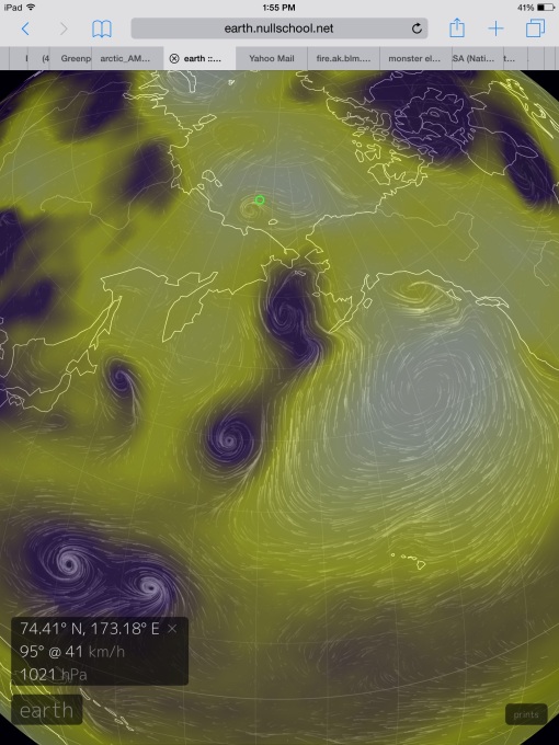 (Pacific
storm track runs from just north of the Equator and on up into the
Chukchi in this GFS model forecast for high [white] and low [purple]
pressure systems on Sunday, August 16th. Is this the track that El
Nino generated storms take as the world warms? If so, there’s more
trouble in store for the Arctic. Image source: Earth
Nullschool.)
(Pacific
storm track runs from just north of the Equator and on up into the
Chukchi in this GFS model forecast for high [white] and low [purple]
pressure systems on Sunday, August 16th. Is this the track that El
Nino generated storms take as the world warms? If so, there’s more
trouble in store for the Arctic. Image source: Earth
Nullschool.)
Then,
according to
GFS model runs,
things start to get interesting. By Sunday, August 16th our massive
Northeast Pacific Ridge starts to really flex its muscles. It
heightens to a near 1040 mb high pressure cell and links arms across
the Arctic with a 1030 mb high over the Central Arctic Basin and
another 1030 mb high over the Barents. In other words, the ridge
forms a transpolar daisy chain. And on the left side of this
transpolar ridge, the storm and moisture conveyor running toward the
Arctic boundary kicks up a notch. Double barrel cyclones fire off in
the region of 15 degrees North Latitude spawning from the very strong
atmospheric feedback of our monstrous-looking El Nino. Three more
storms run in train from 30 North to just past the 70 degree line in
the Chukchi.
And
all run along a diagonal northeasterly track aimed directly at the
Arctic’s thawing heart.
It’s
a new, odd storm track. One that, depending on the strength and
orientation of the Arctic high either ends in the Bering, or runs all
the way to the Pole itself. A heat and moisture delivery system that
begins to take form in August but that, during recent years, has
churned along through Fall, Winter and Spring. It’s a pattern that
in 2015 is fed both by the global warming related hot pool in the
Northeast Pacific and an El Nino still plowing toward off-the-charts
strong. And due to the immense energy of the weather and climate
systems involved it’s an anomalous pattern that risks an extreme
storm potential energy delivery running from Equator to Arctic.
Links:
How
Climate Change Wrecks the Jet Stream, Amps up the Hydrological Cycle
to Generate Extreme Weather

No comments:
Post a Comment
Note: only a member of this blog may post a comment.