

Is there anyone willing to say this is "business-as-usual in the ....Arctic" (Radio New Zealand re Larsen C)
Wildfires
are burning in Greenland
Historically,
wildfires in Greenland occur infrequently.

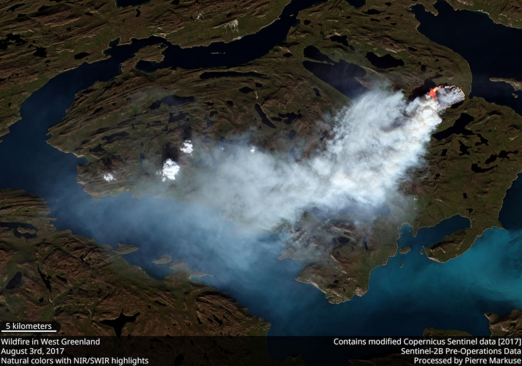
Above: Satellite photo of one of the wildfires burning in Greenland August 3, 2017. Sentinel-2A data from the European Union Earth Observation Programme.
(Originally published at 11:25 a.m. MDT August 7, 2017)
7
August, 2017
Three-quarters
of Greenland is covered by the only permanent ice
sheet outside Antarctica, and permafrost is found on most
of the rest of the island. These are reasons why it is very unusual,
and possibly unprecedented, that two wildfires are burning on the
giant island.
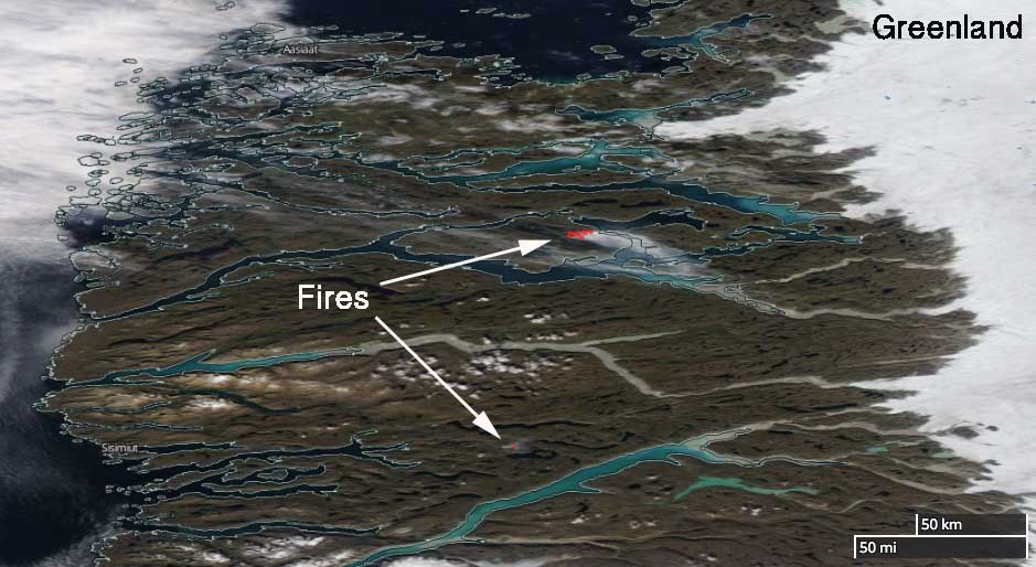
The
fires are near Sisimiut in Western Greenland north of the Arctic
Circle at 66.9 and 67.8 degrees north latitude, which compares to the
“Far North” area of Alaska near the Brooks Range.
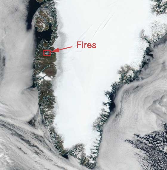
 Satellite
photo showing smoke from the two wildfires burning in Greenland,
August 3, 2017. The red dots represent heat. NASA.
Satellite
photo showing smoke from the two wildfires burning in Greenland,
August 3, 2017. The red dots represent heat. NASA.
According
to Danish and Greenlandic news reports, they were first spotted from
an airplane piloted by Per
Mikkelsen who took photos of the fires.
The weather forecast for the area indicates no rain in the next 10
days.
“These
fires appear to be peatland fires, as there are low grass, some
shrub, and lots of rocks on the western edge of the Greenland Ice
Sheet”, Jessica L. McCarty, an Assistant Professor of Geography at
Miami University told us Monday. She continued, “They are likely
occurring in areas of degraded permafrost, which
are predicted to have high thaw rates between now and 2050 with
some evidence of current melt near Sisimiut. Fires in the High
Northern Latitudes release significant CO2, CH4, N20, and black
carbon. A fire this close to the Greenland Ice Shelf is likely to
deposit additional black carbon on the ice, further speeding up the
melt. More on black
carbon deposition in Greenland from wildland fires can be found
here.”
“The
European Union Earth Observation Programme has stated that wildfires
in Greenland are rare but have no data on previous wildland fire
activity in this region”, Ms. McCarty said.
Vicinity map of the wildfires in Greenland
****
(UPDATE at
3:03 p.m. MDT August 7, 2017)
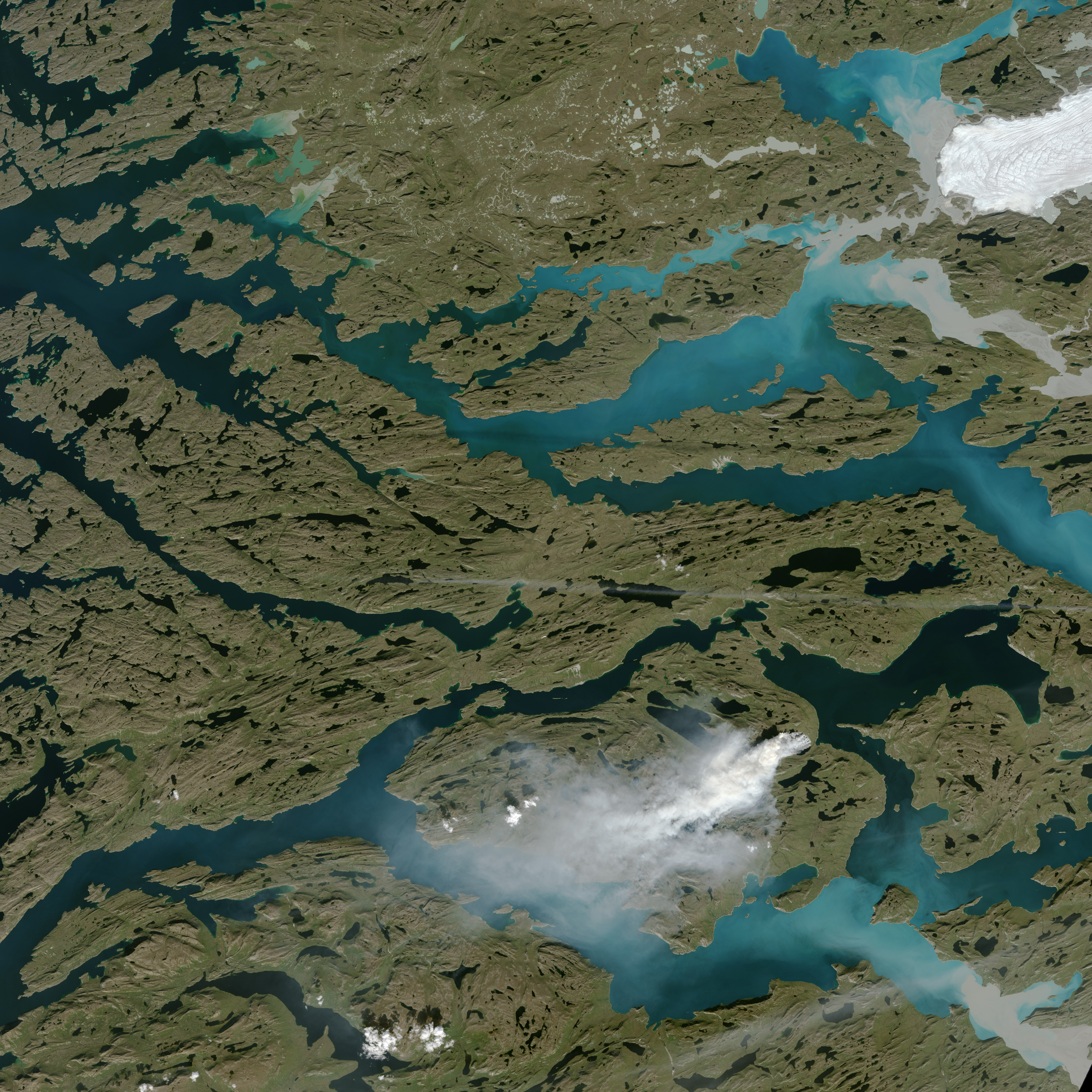
After
we published this article, NASA posted the satellite photo below that
was acquired August 3, 2017 by the Operational Land Imager on
Landsat 8.
 Satellite
photo of the fire in Greenland acquired by NASA August 3, 2017 using
the Operational Land Imager on Landsat 8.
Satellite
photo of the fire in Greenland acquired by NASA August 3, 2017 using
the Operational Land Imager on Landsat 8.
NASA
In
an unusual event, satellites have detected a sizable wildfire burning
in Greenland. The fire is in western Greenland, about 150 kilometers
(90 miles) northeast of Sisimiut. Most of Greenland is covered by
ice, but dwarf willows, shrubs, grasses, mosses, and other vegetation
do live in some coastal areas.
Satellites
first detected evidence of the fire on July
31, 2017.
The Moderate
Resolution Imaging Spectroradiometer(MODIS)
and Visible
Infrared Imaging Radiometer Suite Suomi
NPP collected daily
images of
smoke streaming from the fire over the next week. The Operational
Land Imager (OLI)
on Landsat 8 captured this more detailed image of the fire on August
3, 2017.
While
it is not unprecedented for satellites to observe fire activity in
Greenland, a preliminary
analysis shared
by Stef Lhermitte of Delft University of Technology in the
Netherlands suggests that MODIS has detected far more fire activity
in Greenland in 2017 than it did during any other year since the
sensor began collecting data in 2002. The fire appears to be burning
through peat,
noted Miami University scientist Jessica
McCarty
.
It
is not clear what triggered the fire. Sisimiut, the second largest
town in Greenland, has a population of 5,500 people.
References
- Climate Central (2017, August 7) There’s a Wildfire Burning in West Greenland Right Now. Accessed August 7, 2017.
NASA
Earth Observatory image by Jesse Allen, using Landsat data from
the U.S.
Geological Survey. Caption
by Adam Voiland.
There’s a Wildfire Burning in West Greenland Right Now
By Brian
Kahn
It’s
not just the American
West and British
Columbia burning
up. A fire has sparked in western Greenland, an odd occurrence for an
island known more for ice than fire.
A
series of blazes is burning roughly in the vicinity of Kangerlussuaq,
a small town that serves as a basecamp
for researchers in
the summer to access Greenland’s ice sheet and western glaciers.
The largest fire has burned roughly 3,000 acres and sent smoke
spiraling a mile into the sky, prompting hunting and hiking closures
in the area, according to local
news reports.
 The
Sentinel-2 satellite captured a wildfire burning in western
Greenland.Click
image to enlarge. Credit: Pierre
Markuse/flickr
The
Sentinel-2 satellite captured a wildfire burning in western
Greenland.Click
image to enlarge. Credit: Pierre
Markuse/flickr
There’s
no denying that it’s weird to be talking about wildfires in
Greenland because ice covers the majority of the island. Forests are
basically nonexistent and this fire appears to be burning through
grasses, willows and other low-slung vegetation on the tundra that
makes up the majority of the land not covered by ice.
Data
for Greenland fires is hard to come by, but there is some context for
fires in other parts of the northern tier of the world. The boreal
forest sprawls across Canada, Russia, Alaska and northern Europe, and
provides a longer-term record for researchers to dig into. That
record shows that the boreal forest is burning at a
rate unprecedented
in the past 10,000 years.
Stef
Lhermitte,
a remote sensing expert at Delft University of Technology in the
Netherlands, said there is evidence of fires burning in Greenland
over the past 17 years of MODIS satellite records kept by NASA. But
because of how NASA’s algorithms interpret the satellite data,
there’s low confidence that every fire on the map actually
occurred.
Jason
Box,
an ice sheet researcher with the Geologic Survey of Denmark and
Greenland, said he observed a lightning-sparked fire in the late
1990s, but that otherwise, fires are rare. Looking at the MODIS
record, he said one of the only other high confidence fires was
actually a trash burn in 2013, though other satellites show
evidence of others fires.
Box
also noted that temperatures in the area rose in late July just
before the fire was first observed, spiking to above 53°F (12°C) on
July 27. While not exactly balmy, the temperature rise may have
helped the blazes to spread.
According
to La Croix,
a French newspaper, there’s no precedent for a fire this size in
the European Union’s forest fire system. Looking beyond the
satellite record for context specific to Greenland is all but
impossible as there are basically no records to refer to.
“There
does not appear to be a reliable long-term record of observed
wildfires in Greenland,” researchers with the Danish Meteorological
Institute’s Greenland
monitoring program tweeted.
Ultimately,
it’s not the burning of Greenland’s tundra that’s the biggest
climate change concern. It’s the island’s massive
store of ice that
if melted, would be enough to raise sea levels 20 feet.
The
ice has been melting at a quickening pace since 2000, partly due to
wildfires in other parts of the world. The uptick in boreal forest
fires has kicked up more ash in the atmosphere where prevailing winds
have steered
it toward the ice sheet.
The
dark ash traps more energy from the sun, which has warmed the ice
sheet and caused more widespread melting. Soot from massive wildfires
in Siberia caused 95 percent of the Greenland ice sheet surface to
melt in 2012, a phenomenon that could become a yearly
occurrence by 2100 as
the planet warms and northern forest fires become more common.
No comments:
Post a Comment
Note: only a member of this blog may post a comment.